
|
Links to Information about towns along the Longleaf Trace |
||||||||||
|---|---|---|---|---|---|---|---|---|---|---|
|
How's
business |
Map of the Trace |
|||||||||
|
||||||||||
|
||||||||||
|
||||||||||
Most pictures of
the Trace have been miniaturized to keep the page from
being too slow. Click on the thumbnails to see the pictures full sized.
Official Sign at Jackson Road,
showing the major sponsors
|
Mileage Chart |
||||||||||||
|
Mileage |
Prentiss | Ed Parkman Road | Carson | Bassfield | Lott Circle | Sumrall | Epley | Clyde Depot | Jackson Road | Gateway Southern Miss |
|
|
| Prentiss | Prentiss | 2.8 | 6.3 | 11.0 | 18.3 | 25.1 | 28.9 | 32.7 | 36.1 | 40.2 |
|
|
| Ed Parkman | 2.8 | Parkman | 3.6 | 8.2 | 15.5 | 22.3 | 26.1 | 30.0 | 33.3 | 37.5 |
|
|
| Carson | 6.3 | 3.6 | Carson | 4.6 | 11.9 | 18.8 | 22.5 | 26.4 | 29.8 | 34.0 |
|
|
| Bassfield | 11.0 | 8.2 | 4.6 | Bassfield | 7.3 | 14.2 | 18.0 | 21.8 | 25.3 | 29.5 |
|
|
| Lott Circle | 18.3 | 15.5 | 11.9 | 7.3 | Lott | 6.8 | 10.5 | 14.4 | 17.8 | 22.0 |
|
|
| Sumrall | 25.1 | 22.3 | 18.8 | 14.2 | 6.8 | Sumrall | 3.8 | 7.6 | 11.0 | 15.2 |
|
|
| Epley | 28.9 | 26.1 | 22.5 | 18.0 | 10.5 | 3.8 | Epley | 3.9 | 7.2 | 11.4 |
|
|
| Clyde | 32.7 | 30.0 | 26.4 | 21.8 | 14.4 | 7.6 | 3.9 | Clyde | 3.4 | 7.6 |
|
|
| Jackson Road | 36.1 | 33.3 | 29.8 | 25.3 | 17.8 | 11.0 | 7.2 | 3.4 | Jackson | 4.1 |
|
|
| Gateway Southern Miss |
40.2 | 37.5 | 34.0 | 29.5 | 22.0 | 15.2 | 11.4 | 7.6 | 4.1 | Gateway Southern Miss |
|
|
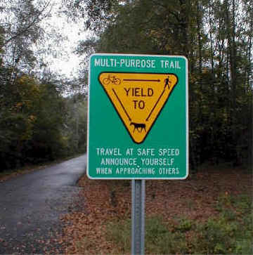
The Trace is now officially open and is being used daily by many bikers, runners, and hikers. BE CAREFUL. All the signs are up to both motorists and trail users of crossroads. There are many intersections of logging roads and seldom used access roads. But don't be lulled into complacency by these sleepy crossings. The next crossing, which looks very similar from a few yards away, may be a major thoroughfare, with vehicles coming at you at 55 mph.

As the sign shows, walkers should
yield to equestrians, and bikers
should yield to both walkers and equestrians. Be courteous and let
other trail users know of your approach. Even if there is plenty of
room
to pass, give a warning. A jogger may hear your bicycle coming at
the
last second and (as recently happened) try to get out of your way in the
wrong direction. Horses are also easily startled, and a startled horse can
be very dangerous for the rider, and even more dangerous for the
walker/biker/skater that startled him. In all cases, be sure the other
party knows you are there before passing.
The mile maker signs show mileage (from the downtown train station, as per the
old railroad markers, not the distance on the trail), the corresponding
kilometers, and mile sponsor.
Click on the thumbnail to see
the picture described.
Parking Area and Rest Room at Jackson Road, 1/2 mile north of 4th Street
Beautiful fern bank 1 mile from
Jackson Road
A special feature now fully operational is a rest stop at Clyde, about 3 miles from Jackson Road. Built and originally operated by Mr. and Mrs. Bond, who live adjacent to the stop, it has a rest room, picnic tables, and drink machine. It can be reserved for groups. To reach Clyde by car, turn off 4th street onto Railroad Avenue. The Bonds live on the right just before the trail and the station.
![]()
![]()
![]()
Here is the text of several
notices posted in the shelter area at the depot.
Several scenic ponds are passed
on your way to Sumrall
Parking Area and Rest Room at Epley. This is just off Highway 589 at Epley
Road

The trail leaves Epley, heading
west toward Sumrall. Note the
horse and mountain bike trail (just to the right of the paved trail).
This side trail covers 25 miles from Epley to Carson.
Paved trail to the left, horse trail on the right, between Epley and Sumrall.
Californian Aimee Meyer on Bandit
(left), and Nicole Blackburn on Doc,
unload at Epley and start out the horse trail
Much of the trail is well shaded,
with wonderful natural landscaping.
Deep cuts and high embankments through low areas add to the interest.

The Parking Area in Sumrall
is at Railroad and Center Streets, next to the Post Office
Heath Sumrall is building a bike
shop, snack bar, game room, and golf cart complex next
to the Trace in Sumrall. He is already renting golf carts and selling
snow-balls.
Call him at 758-4900.
Sumrall Mayor Darwin Graham and his
wife Evelyn enjoy a morning walk on the Trace
Several persons
have reported taking a very pleasant bicycle trip to Sumrall, eating lunch
at Lau-Tori's, and returning. The service is reportedly
good, the food excellent, and the prices
very reasonable. The restaurant is just off the Trace; take the side road
paralleling the Trace
to your right (going west) as you cross Center Street (the main street) in
downtown Sumrall.
Po-Boy's, Cajun fries, and fried ice cream!

Lau-Tori's Fine Foods in Sumrall,
and their new bike rack under the trees.
Just west of Sumrall two sturdy
bridges cross small streams.
This one was sponsored by Bobby Chain, one of the Trace's early
supporters.
Ms. Gladys has a beautiful flower
garden along the trail west of Sumrall at B. Morris lane.
You get a chance to meet local
residents on the trail. Here the Ryders and Ann
talk to Willie Taylor, Marcus Owens, and Elijah four miles from Bassfield.
There are several gravel parking lots especially suitable for horse
trailers. One is in Carson,
and this one is at Lott Circle between Bassfield and Sumrall. Both are
visible from highway 42.

![]()
Four K Stables is a deluxe stable near the Trace in
Bassfield, and has parking
for horse trailers, RV's, and large groups. See pictures
of their facilities.
Primitive campers are also welcome, plus a bunk house is available.
See the 4K Stables web site
for more details.
To get to 4K from Highway 42, turn at the Texaco station and go 1 block to
General
Robert E. Blount Boulevard. Turn right and 4K will be the first gravel drive on
your
left (Just after Jefferson Street)
The Trace passes through downtown Bassfield.
Another view of downtown
Bassfield from the Trace.
Access parking lot just west of
Bassfield at Garroway Road and Hwy 35.
There is an RV dumping station at this parking lot, and a Ward's nearby.
Note park benches if you want to stop and rest awhile.
A picnic pavilion erected by
Johnny Kerley in memory of his father,
Jack Kerley, is just across the Trace from the parking area in Bassfield
More pictures in Bassfield
Parking area along 42 across from the Post Office in Carson.
Also see pictures of trailer parking and
primitive camping area.
A new picnic pavilion along the Trace
in Carson
Historic Bank in Carson just off the
Trace. (now being dismantled)
You pass several more bridges going
west from Carson.
Another
access parking area 3 miles from Prentiss at Ben Parkman Road.
A long bridge
just east of Prentiss, sponsored by Lamar Bank.
The Trace ends in downtown Prentiss
in a beautifully landscaped park.
![]()
![]()
![]()
More pictures of the Prentiss
park, including a group of riders passing the sponsor sign
(Pictures courtesy of Laurie Sears)
![]()